Skip to content

Wolfe’s Neck Center Research Intern Shares SOC Maps for Wolfe’s Neck and State of Maine

image1

The measurement of soil organic carbon (SOC) is a complex and contested process that essentially boils down to two measurements: total carbon and bulk density. Total carbon is usually measured in a laboratory using the dry combustion method, whereby a soil sample is heated and all carbon compounds are decomposed and converted into measurable carbon oxides. To estimate the SOC in an area of land, bulk density measurements can be used to adjust total carbon levels for varying soil densities / concentrations across the soils. Both of these processes are time- and labor-consuming, which makes measuring carbon on the farm a challenging process. 

Because the measurement of SOC stores is such an intense process, people have begun to look to environmental indicators of SOC sequestration capacity. Soil type is a leading determinant, as more clay-heavy soils are able to sequester more carbon. Similarly, land cover can determine potential. For example, large trees pull more carbon out of the atmosphere, while barren land does not pull much at all. Other factors like land gradient, temperature, and precipitation also affect plant establishment and growth, and therefore contribute to sequestration rates. Spatial analysis helps us understand where sequestration is most feasible, and perhaps where carbon removal practices and management strategies should be implemented. 

Wolfe’s Neck Center has been conducting research into soil organic carbon for several years. This year, we have collected upwards of 100 soil samples for various purposes. Due to the complex nature of SOC measurement, there are many tools in development designed to reduce the burden of measurement. Some creators have been working with OpenTEAM and Wolfe’s Neck Center to calibrate and/or pilot their devices. Generally, we have worked with creators of in-field spectrometers, which attempt to take a soil sample, save the location, and record the SOC content of the sample in the field. In order to calibrate these devices, we have also sent samples to laboratories to receive routine soil analyses in addition to official SOC measurements. 

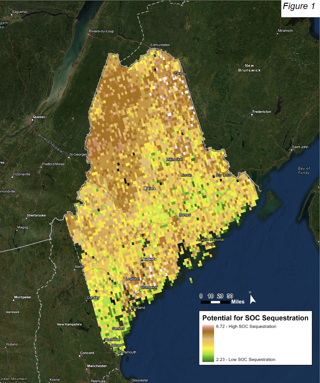
Informed by this data collection process, research intern Charlotte Mondale sought to create a map to predict zones in Maine that are expected to have a higher soil organic carbon (SOC) sequestration rate than others. Environmental factors were considered in order of their influence on sequestration potential: soil type (weight of 40%), land cover (30%), slope aspect (12%), slope gradient (8%), mean annual precipitation (5%), and mean annual temperature (5%). A weighted suitability analysis, conducted with a raster calculator, determined the zones in Maine that are expected to have the highest SOC sequestration potential.

The final suitability analysis indicates areas in Maine that would be expected to have high SOC sequestration potential, indicated by the color brown. Generally speaking, these areas are concentrated in the south, with some dark green (high potential) zones scattered throughout the north as well. This more or less aligns with the distribution of Maine agricultural land, which is concentrated in the relatively more developed coastal and southern regions. These results indicate where a local or county-wide sequestration activity would be best suited in order to yield maximum removal of carbon from the atmosphere.

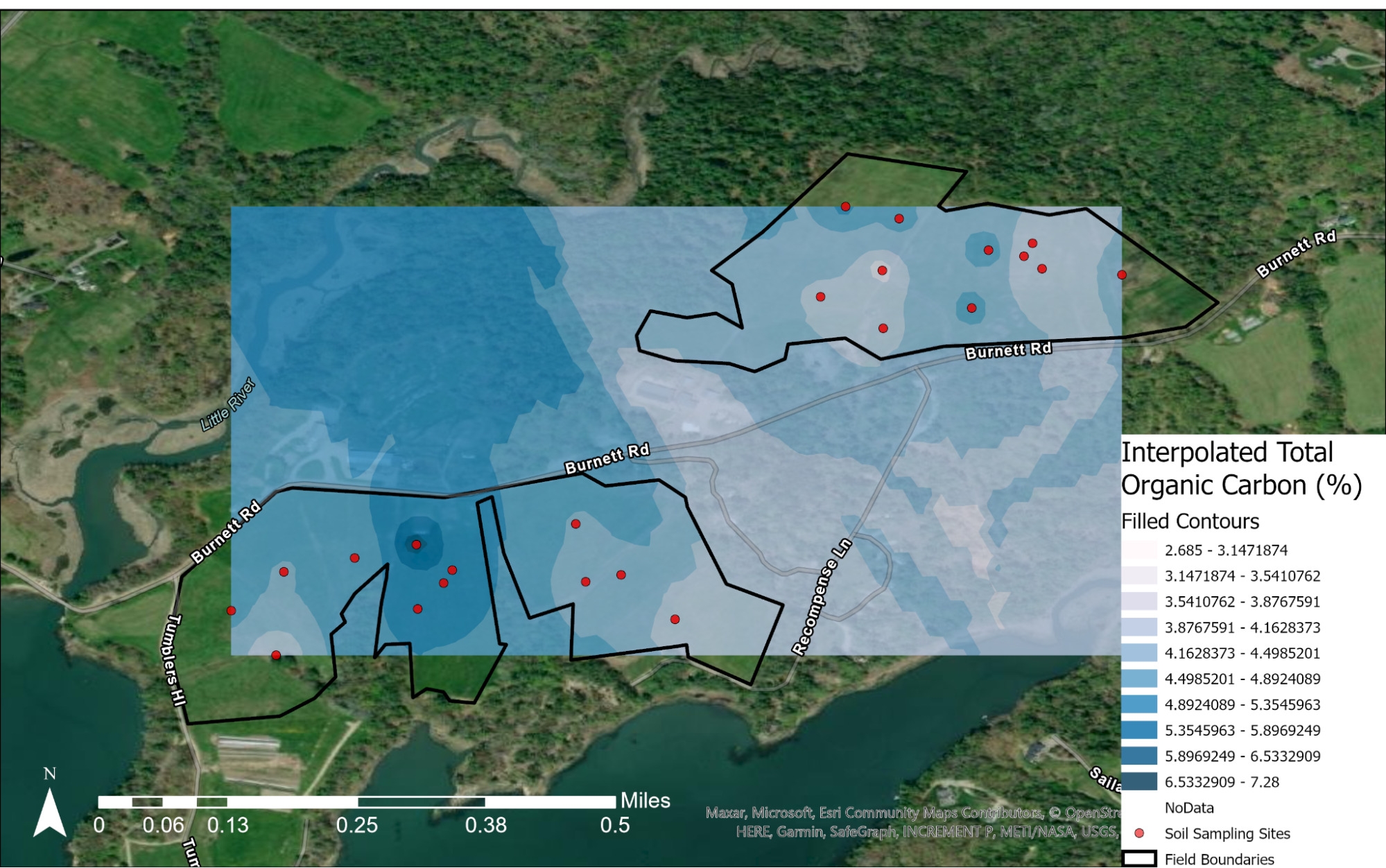
This map of Wolfe’s Neck shows the interpolated soil organic carbon levels for the Brocklebank and Bay fields. Interpolation refers to the mathematical process of inferring values based on inputted data. In other words, the red points indicate points where we took soil samples and had them lab tested for actual SOC levels. The shades of blue around the points illustrated expected carbon stores for the surroundings. This map indicates that there is more SOC concentrated around Middle Bay. This makes some sense, because this is our primary grazing pasture; the land is particularly rich thanks to cow manure. This area also has relatively good drainage, allowing for water to percolate through the soil as well as run off when there is an excess.

Facebook
Twitter
LinkedIn
Pinterest

No comment yet, add your voice below!


Add a Comment

Your email address will not be published. Required fields are marked *

Lorem ipsum dolor sit amet, consectetur adipiscing elit. Ut elit tellus, luctus nec ullamcorper mattis, pulvinar dapibus leo.